Back to Home
Page of CD3WD Project or Back to list of CD3WD Publications
 |  |  | Soil and Water Conservation (SWC) Technologies and Agroforestry Systems (IIRR, 1992, 171 p.) |  |  | Options for contour farming: | |  | 1. Establishing Contour Lines | | | 2. Sloping Agricultural Land Technology (SALT-1) | | | 3. Rockwalls | | | 4. Vetiver for SWC | | | 5. Uses of Grasses in SWC | | | 6. Simple/Double Selection of Hedgerow Species | | | 7. Contour Canals | | | 8. Bench Terraces |
|
Soil and Water Conservation (SWC) Technologies and Agroforestry Systems (IIRR, 1992, 171 p.)
Options for contour farming:
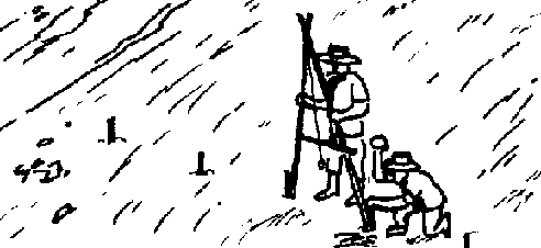
1. Establishing Contour Lines

Contour line
INTRODUCTION
A central element of soil conservation on sloping land is
thecorrect establishment of contour lines. If contour lines are incorrectly
established, then they can actually increase the risk of erosion. Therefore, it
is very important that farmers understand the concept of contour lines and are
initially assisted to correctly establish these.
PRINCIPLE
Contour lines are lines that nun across a (hill) slope such that
the line stays at the same height and does not run uphill or downhill. Contour
lines are used in the establishment of hedgerows, pasture strips, canals, etc.
DISTANCE APART
Generally, contour lines are established so that the vertical
distance between the lines does not vary. For erosion control, the rule of thumb
is: vertical fall between contour lines is about 1 meter on steep slopes (above
15 percent), reducing to 0.75 meter on greater slopes (below 15 percent).

The horizontal distance between two
contour lines will vary as the steepness of the slope changes.

The steeper
As contour lines travel across a hillside, they will be close
together on the steeper parts of the hill and further apart on the gentle parts
of the slope.

Contour lines
HOW TO ESTABLISH CONTOUR LINES
1. Use an A-frame, O-ring or water level to determine the
contour lines. (See pages 37-38).
2. Start in the middle of the slope, work down to the bottom of
the area, then work upwards to the top. By starting in the middle, you minimize
cumulative errors. Some people prefer to start work in the steep section, some
at the top.
3. Make sure that the base of the instrument stands as a
representative site (not in a hole or on a hill).
4. Ignore small disruptions to the general slope.
5. Place stakes at least every 3-6 meters along the contour line
or closer if desired (every first pivot of the A-frame). Make sure that stakes
are driven well into the ground. Place the stakes closely (3 meters) if the
ground cover is tall or dense and/or if the slope is steep with rapid changes.
6. The vertical spacing (1 meter) between contour lines can be
measured by sighting over a "T-stick" of appropriate height (1 meter) back to
the previous contour line (working downhill: or from the previous contour line
uphill (working uphill).
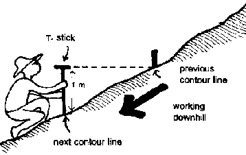
Working downhill

Working uphill
INSTRUMENTS
1. A-frame (See Making an A-frame on pages 1001 03.)
with carpenter's level
with string plumb
bob
2. O-ring
To make:
· Fill
one-meter length of clear plastic tube (15 mm diameter) half full with colored
water using the extracts from achuete or duhat.
· Form the tube into a circle by
bending it into a circle and inserting one end into the other end. Heat or hot
water may be used to soften the outer end to make it easier to insert the other
end into it.
· Attach the ring to the top of
a stick. String, tape or nails can be used to attach the ring to the stick. The
stick should be about as tall as the person using it. The level of the water in
the Oring will then be at eyeheight.
· Make another stick (staff) the
height of the water level in the tube. A small bar painted a bright color for
visibility can be attached to the top of the stick.
To Use:
One person holds the stick with the ring while another holds the
stick with the bright-colored bar. The person with the ring directs the person
with the bar who stands 36 meters away to move up or down the hill, using the
water levels in the ring and the top of the bar as guides. The site is correctly
located when the water in the ring is level with the top of the bar. A stake is
placed at the foot of the stick with the bright-colored bar.

O-ring
3. Water Level
To make:
· Purchase eight
meters of dear plastic tube (510 mm diameter).
· Attach the ends to two sticks
of equal height (two meters) with a mark at the eye-level leaving about 50 cm.
of tube above the eye level mark.
· Fill the tube with colored
water to the level of the top of the two eye-level marks. Then, seal the ends of
the tube.
To Use:
· One person holds
one stick, another person takes the other stick out along the contour and
locates the site where the water level is steady at the eye-level marks. A stake
is driven at this spot.
· The two people then move so
that the first person walks to the site of the second and the second moves to a
new site along the contour.

Water level
Helpful hints:
1. Study the land first and visualize where the contour lines
will run.

Same level
This may be done best by having one person direct another person
in walking to the other side of the area to be contoured such that he/she stays
at the same height as the first person.

People
Also try to visualize what the area will look like when terraced
-- particularly the height and width of the terraces. This can be assisted by
using a "T-stick" and string.

Using a “T-stick”
2. Always look behind at the line of stakes and assess whether
you are running level.
3. Get a feel for the main direction of the slope. The contour
line will run perpendicular to this direction.
4. Establish your contour lines at a time when labor requirement
for other farm operations is low.
However, do not leave the stakes for a long time before
cultivating or sowing because the stakes may be displaced by livestock or
children.
5. Land that has been cleared but not cultivated best to work
on. If the land has been cultivated, the site for placing the staff or leg of
the A- frame should be roughly levelled with the foot.
6. Cultivation of the whole area creates problems in
establishing seeds or seedlings because heavy rain will wash away seeds and
seedlings.
7. Encourage neighboring farmers to work together to plan the
contouring and layout of hillsides. In this way, contour lines can be connected
and drainage systems protected.
8. If stakes are close together when plowing or seeding, do not
follow the exact contour line from peg to peg (Doing so will create a zigzag
line), but look ahead and smooth out the line by taking a line of "best fit"
between the stakes.

Smooth out the zig-zag
line
2. Sloping Agricultural Land Technology (SALT-1)

Land lines
SALT-1 is a one-hectare model of agroforestry technology with
agricultural and forestry crops at a percentage of 75:25. Based on the
experience of the Mindanao Baptist Rural Life Center (MBRLC) in Bansalan, Davao
del Sur, this technology decreases erosion by 50 percent, as compared to the
traditional upland farming system. In addition, it increases com yield by about
five times and income by six times.
This information material will guide you on how to establish
SALT-1.
SALT is a simple, applicable, low-cost and timely method of
farming the uplands. This technology was developed for farmers with few tools,
small capital and little knowledge in agriculture. A farmer can continue his
traditional farming practices in the SALT system.
If farmers leave the SALT farm, like some tribals in Mindanao
do, the nitrogen-fixing trees and shrubs (NFT/S) will continue to grow and
overshadow the crop area. By the time the land is again cultivated, the soil has
already been enriched by the large amount of leaves from the NFT/S, which also
prevents erosion. In addition, the NFT/S, particularly the woody species, may be
harvested for firewood or charcoal as additional source of income. Findings of
MBRLC show that a hectare of SALT farm can provide an income of P1,3001ha/mo as
against the P200/ha/mo in upland farms of corn cultivated the traditional way.
Another benefit of SALT-1 is that it is less laborious than the traditional
method of upland farming.
Here's how to put SALT-1 in your hillyland:
Step 1: Make an A-Frame. The A-frame is a simple device for
laying out contour lines across the slope. It is made of a carpenter's level and
three wooden poles nailed together in the shape of a capital letter A with a
base of about 90 cm. The carpenter's level is mounted on the crossbar. (Other
methods of making an A-frame are discussed in Making an Aframe, pages 100-103.)

A-stick
Step 2: Locate the contour lines using the A-Frame. One leg of
the A-frame is planted on the ground; then, the other leg is swung until the
carpenter's level shows that both legs are touching the ground on the same
level. A helper drives a stake beside the A-frame's rear (first) leg. The same
level-finding process is repeated with stakes every five-meter distance until
one complete line is laid out. The distance of contour lines is three to five
meters apart.

Locating
Step 3: Prepare the contour lines. After finding and marking the
contour lines, prepare them until ready for planting. The width of each area to
be prepared should be one meter. The stakes will serve as guide during plowing

Preparing
Step 4: Plant seeds of nitrogen-fixing trees and shrubs
(NFTS/S). On each prepared contour line, two furrows are laid out. Plant two to
three seeds per hill at a distance of one-fourth inch between hills. Cover the
seeds firmly with soil. When fully grown the hedgerows bank the soil and serve
as source of fertilizer. Examples of hedgerow species are Flemingia macrophylla
(syn. congests), Desmodium renzonli, Calliandra calothyrsus, Gliricidia septum,
Leucaena diversifolia and L. Ieucocephala.

Planting seeds
Step 5: Cultivate alternate strips. The space of land between
the thick rows of nitrogen-fixing trees and shrubs where the crops are to be
planted is called a strip or alley. Cultivation is best done on alternate
strips. Altemate cultivation will prevent erosion because the unplowed strips
will hold the soil in place.

Strips
Step 6: Plant crops. The permanent crops like coffee, cacao,
banana, citrus and others of the same height may be planted at the same time the
nitrogenfixing species are sown., In areas which are not cultivated, only the
spots for planting are cleared and dug and, later, only ring weeding is employed
until the hedgerows are large enough to hold the soil in place. Plant permanent
crops in every third strip. Tall crops should be planted at the bottom of the
farm to avoid shading.

Citrus + Banana
Step 7: Plant short-term crops. Plant short and mediumterm
income-producing crops (pineapple, ginger, taro, potato, peanut, mung bean,
melon, sorghum, corn upland rice, etc.) between the strips of permanent crops as
a source of food and regular income while waiting for the permanent crops to
bear fruits. To avoid shading short plants are planted swan from tall ones

Short term planting
Step 8: Trim the contour hedgerows regularly. One year after
planting the hedgerows, cut the hedgerows at a height of 40 centimeters from the
ground every 30 to 45 days. Always pile the cut leaves and twigs at the base of
the crops. These cuttings serve as an excellent organic fertilizer for the
crops.

Trim the contour
Step 9: Rotate your food and cash crops. A good way of rotating
is to plant cereals corn, upland rice, sorghum, etc.), tubers (sweet potato,
cassava, gabi, etc.) and other crops (pineapple, castor bean, etc.) on strips
where legumes (mung bean, bush sitao, peanut, etc.) were planted previously and
vice versa. This practice will help maintain the fertility and good condition of
the soil. Other management practices in crop growing like weeding and pest
management should be done regularly.

Rotating
Step 10: Maintain your SALT-1 farm. Apart from providing you
with adequate food and sufficient income, an even more important benefit of
using SALT-1 is the control of soil erosion. This is done by the double thick
rows of NFT/S and the natural terraces being formed along the contour lines of
the hill. To enrich the soil and effectively control erosion, always pile
straws, stalks, twigs, branches, leaves, rocks and stones at the base of the
thick rows of nitrogen-fixing species. As the years go by, strong, permanent and
naturally green terraces will be formed which reliably anchor the precious soil.

Maintaining
SALT-1 can be adapted throughout the country, particularly in
the uplands. SALT-1 is now being adopted in several Asian countries, among them
Indonesia, India, Thailand, Sri Lanka, Nepal, Cambodia, Vietnam, Nigeria and
Congo. But even then, MBRLC believes SALT-1 is not a perfect farming system
despite its popularity. No system can bring depleted, eroded soil back into
production in a short span of time. But land can be restored, upgraded and
sustained to a reasonable level of productivity by using SAL Tel.
Table 1. ADVANTAGES OF SALT-1 OVER THE TRADITIONAL UPLAND
FARMING SYSTEM.
|
TRADITIONAL FARMING |
SALT-1 |
|
Soil erosion |
194.3 m.tJyr |
3 4. m.t./yr |
|
Crop productivity |
less productive |
more productive |
|
Net income |
P300.00 |
P1,300.00 |
|
Labor |
High Labor |
Low labor |
|
Hedgerows |
None |
Two strips |
|
Organic fertilization |
None |
Free 3,000 kls. biomass/ha/yr |
During its establishment, SALT-1 is more laborious (planing of
hedgerows and permanent crops) than the traditional farming In the subsequent
years, SALT-1 decreases its labor requirements (cultivation and weeding is
lessened; only pruning is practiced); whereas, in traditional farming, constant
cultivation, regular planing of crops and regular weeding are still required.
Source: MBRLC Editorial Staff (1990). How to Farm
your Hilly Land Without Losing Your Soil. MBRLC, Kinuskusan, Bansalan Davao del
Sur. 24 pp. How to Serbs No.1
Nob: The crops mentioned earlier are just suggestions. Farmers
can use other crops suitable to their
areas.
3. Rockwalls
Contour rock walls are soil conservation structures which are
generally constructed where there is an abundance of rocks. The technology is
very labor intensive and is generally accomplished through labor exchange groups
(i.e., bayanihan, alayon) rather than individually. The structure is more
permanent than other soil erosion barriers. Several steps are involved in
rockwall construction.

Steps
1. Starting from the upper side of the farm lot, excavate a
drainage canal which gently slopes (1121%) towards a nearby gully. The canal
will prevent water from flowing onto the farm from the land above.
2. Use an A-frame to mark a contour line on the hillside and
below the drainage canal. Smooth the curve of the contour line.

Excavate
3. Excavate a base for the rockwall between 50-100 cm wide,
10-25 cm deep, and with a reverse slope to the base (i.e., slopes downward from
the edge of the slope onto the hill.)
4. Begin construction by using large rocks for the base. The
flatter, heavier sides should be placed outward. Smaller stones are used to fill
in spaces between larger stones. Do not use small rocks for the base and place
large rocks on top. This is unstable. Build one layer at a time. Tamp the stones
to make the layer firm before starting another layer.

Constructing
5. The height of the rockwall will vary but, if possible, should
reach the vertical height of the mid-line between the contour lines. If a
shorter wall is initially constructed, it should be raised if the soil caught
behind it reaches the top.
6. The sides of the rockwall should be gently angled for
stability. The top should have a smaller width than the bottom. Generally, the
top width of 50-70 cm is used for a onemeter-wide base. Walls shorter than one
meter have narrower tops.
7. Rock walls should be constructed 3-5 meters apart for steep
slopes, 5-10 meters apart for medium slopes and up to 20 meters apart for very
gentle slopes.
8. During heavy rains, soil will erode from the base of the
downhill side. The depression created will eventually enlarge, creating an
unstable situation. The wall may eventually fall. Regular maintenance and
suggestions listed below will help solve this problem.

Scouring
9. To further stabilize the rock wall and reduce the chance of a
washout, Glincidia or other fast-growing legume trees can be planted 10 cm from
the wall and 15 to 30 cm apart within the row on the downhill side. The legume
trees below the wall will help hold it in place. It can provide firewood, forage
fertilizer and windbreakers.

Wall
10. Napier or other forage grasses can be planted on the upper
side of the wall. Newly eroded soil will wash down the hill and be caught behind
the wall. This will help fertilize the grasses. The grasses can, be used as
forage or fertilizer (i.e., green manure, mulch).

Wall
CONSIDERATIONS
1. In many places, rockwall construction is a continuous
process. Because of the labor input, only a portion of the wall may be
constructed at any one time. The wall gradually increases in height as rocks are
cleared from the field and as more time is devoted to the activity.
2. There are examples of rockwalls combined with other soil
conservation technologies. One example is the combination of a canal, hedgerow
and rockwall. The hedgerow is planted directly above the canal while the
rockwall is built along the upperside of the hedgerow. Bench terraces are often
combined with rockwalls. In this case, the rockwall stabilizes the terrace
riser. (See Terraced Agricultural Land Technology, page 81.)
3. Sometimes, grasses are placed below the wall. If this is
done, Vetiver grass (Vebvera zizanioides) is recommended. The planting distance
is 10-15 cm from the wall and 30 cm between clumps.
4. If napier grass is planted on the upper side of the wall,
care must be taken to manage the grass. Napier tends to spread out and will
invade the cropping area if not regularly cut. This is not so much a problem if
a clump grass, such as Guinea grass, is used. Napier or other grasses can serve
as homes to rats and other pests if not regularly inspected and harvested.
5. Rockwall systems should be tied up to the overall soil
conservation system in the farm. This is critical if there is excess water
accumulating behind the rockwall and must be safely removed from the area.
6. Rockwalls have many empty spaces in between rocks which can
become the home of agricultural pests such as rats and snails. Successful local
methods to solve these pest problems are: (a) regular inspection while using a
dog to locate and chase the rats and (b) regular hand-picking of larger snails
while employing one or more ducks to eat the baby snails.
7. Farmers have used legume trees planted below the rockwalls in
different ways. Among these are: (a) allowing one tree to grow taller at 5 m
spacing and cutting it as firewood when thick enough; (b) cutting the hedgerow
at 1 meter height for forage and/or green manure fertilizer; and, (c) allowing
the tree to grow two meters and keeping it pruned at that height so it acts as a
windbreak for the area behind the rockwall.

Legumes trees as windbreakers
One practice made by IIRR to prevent leguminous trees (i.e.,
ipil-ipil) from jumping lice (psyllid) attack is to pollard them higher than
normal (above 2 meters). In this manner, the birds could easily pick on the
psyllids, thus, putting them under control and lessening the threat of damage or
of drying up during drought
periods.
4. Vetiver for SWC
Vetiveria zizanioides L. Nash, also known as Vetiver grass,
Khus, Moras or Mura is densely tufted, perennial clump grass, with stiff leaf
blades. The foliage is mostly basal with the leaf sheaths closely overlapping,
strongly compressed and keeled which creates a physical barrier of great density
at the ground surface.

Vetiver grass
VETIVER GRASS:
THE RECOMMENDED PLANT
Vetiver grass has the following characteristics that make it
ideal for permanent, effective and simple to establish and maintain soil and
water conservation measures:
1. It is easy to propagate and establish as a hedge.
2. It is adapted to a wide range of soil and climatic condition.
3. When planted correctly, vetiver grass will form a dense
permanent hedge in less than one year.
4. It has a strong root system that penetrates and binds the
soil.
5. It is perennial and requires minimal maintenance.
6. It will not spread to the alleys since it does not spread by
rhizomes nor from seeds.
7. Its crown is below the ground surface which helps protect the
plant againts fire and overgrazing.
8. Its sharp leaves and aromatic roots are reported to repel
rats, snakes and other pests. However, if leaves are not pruned, maya birds
(Lonchura ma/acca) have been found to build nest among its dense leaves
attracting snakes and rats.
9. Its leaves and roots have demonstrated a resistance to most
insects and diseases.
10. It is generally unpalatable to livestock. The young leaves,
however, can be used as fodder, especially during drought.
11. It can withstand drought, flood and long periods of
waterlogging.
12. Vetiver hedgerows have minimal space requirements.
13. It does not compete as much with the crop plants it is
protecting compared with other grasses.
14. It is compatible with any crop (e.g.' com, sweet potato,
vegetables) or other hedgerow grass and legume species (e.g., rapier, ipil-ipil,
madre do cacao, etc.).
15. It is abundant in many places in the country.
STEPS IN ESTABLISHING VETIVER HEDGES
1. Locate the contour lines using an A-frame and make the
furrows.
2. Prepare the planting materials:
· Dig the vetiver
clumps with a digging flat bar.
· Tear a
handful of the vetiver grass from the clump and further sever the root divisions
or slips.
· Cut the leaves 15-20 cm from the
base.
· Trim the roots 8-10 cm below the
base.

Trim the roots
3. Just like planting rice seedlings, plant one or more slips in
single rows along the contour furrows 10-15 cm apart at the start of the the
rainy season

Planting the roots
4. Replant dead vetiver slips for gap filling.
5. Trim the vetiver hedges 40-50 cm from the ground after they
have properly established to encourage tillerino and avoid shading of adjacent
cross.

Trim the vetiver
6. Plant fast-growing leguminous trees/shrubs every 2 m just
above the vetiver furrow lines and prune no less then 1.5 m 1 m high
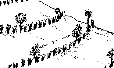
Pruning
7. Vetiver can be planted below contour bunds It can also be
paired with leguminous tree and shrub species planted on the upper side of the
bund.
Vetiver grass is used extensively in India for control of sheet
erosion on vertical soils or flat lands. It also serves the purpose of a fire
break.

Figure
The leaves are sometimes used for mulching and rooking.
References:
Vetiver Grass (Vetiveria zizanioldes): A Method of Vegetative
Soil and Moisture Conservation. 2nd Edition. J.C. Greenfield, Works Bank. New
Delhi. April 1 988.
MURA Ang Tanom nga Mopugong sa Pagkeanas sa Yuta. Basahon I,
FARMI, ViSCA, Baybay, Leyte. 1991. OnFamn Research Notes. Issue No. 5, FARMI,
VISCA, Baybay, Leyte, Febnuary
1991.
5. Uses of Grasses in SWC
Grasses play an important role in stabilizing sloping areas.
Species like rapier/elephant grass (Pennisetum pupereum), Guinea grass (Panicum
maximum) and NB21 (rapier crossed with pear' millet) grow vigorously and are
ideal for their soil-binding properties. They are also good sources of fodder
for livestock. However, if the farmer is more interested in essential oils
rather than livestock, he can plant citronella (Cymbopogon nardus Jowitt) and
lemon grass (Cymbopogon citratus Stapt). Grasses have the advantage of
establishing easily although they could compete for moisture in waterlimited
situations.
GRASSES AS SOIL BARRIERS
Plant the grasses along the contour lines to minimize surface
runoff/erosion in cultivated sloping farms Soil will begin to collect behind the
grass barrier even within the first year of establishment.

Soil barriers
Where feasible, contour earth bunds may be constructed and then
planted with grass to stabilize the structure against breakages or breaches.
Grasses must be regularly trimmed and used as feed for livestock or as mulch for
the crops. Trimming of stems and clumps reduces shading and controls growth.
Otherwise, the untrimmed grass may become a problem (i.e., it may later be
considered a weed).

Soil barriers
GRASSES AS SOIL BINDERS
Stabilizing grass species have also been proven effective in
firming up the riser of terrace structures. They prevent soil erosion and the
collapse of the terraces.
The space between the drop structures, the bed and the sides of
the waterways should be well-sodded with guinea grass to protect it from erosive
water. In addition, rows of napier grass 40 cm apart can be planted along the
lip/edge of the terrace. This will increase the protection of the risers,
discourage farmers from cultivating the edge and provide an additional source of
forage.
Note: The limitation of this grass-based technology is the lack
of nitrogen-rich green leaf manure that fast-growing leguminous trees could
provide.

Napier grass and guinea
grass
6. Simple/Double Selection of Hedgerow Species
The adoption of alley cropping or contour farming using living
hedgerow barriers continues to gain popularity with farmers in the Philippines.
The initial success.with ipil-ipil (Leucaena leucocephala) was followed by a
devastating infestation of the jumping plant lice (Heteropsylla cabana). This
pest eliminated much of the ipil-ipil in the country and caused farmers,
technicians and scientists to reconsider the use of a single species in alley
cropping hedgerows. This experience has stimulated trials with a wide range of
plant species and had reinforced the need for diversification in hedgerow
planting.
It is important to select carefully the hedgerow species which
are suitable to local conditions and the needs of individual farmers in discrete
locations. The range of useful species offers many options for farmers; however,
they must consider carefully the objectives and constraints they are working
under. Selection of species for hedgerows should include the following
consideration:
1. Main objectives
- erosion control
- legume or fixes nitrogen from the
air
- fuelwood
- green manure
- livestock fodder
- herbage
production
2. Rainfall
- amount and distribution (number of dry months)
- drought
tolerance
3. Type of soil
- textural characteristics
- depth
- pH; acidJalkaline -
fertility 4. Elevation 5. Others
- pruning tolerance
- deep-rooted or
tap-rooted propagation
- germination ability/livability of planting materials
nitrogen-protein content
- availability of planting materials/seeds -
origin
- pest resistance
The main hedgerow species are perennial members of the legume
family. In addition, several types of grasses have been used. The list of the
key plant species which are currently being utilized as hedgerow species in the
Philippines, with information on their suitability under the various conditions
described earlier is shown in Table 2.

Peasant
TABLE 2. HEDGEROW SPECIES
|
SCIENTIFIC NAME |
COMMON NAME |
USES' |
ELEVATION (meters) |
DROUGHT TOLERANCE |
pH TOLERANCE |
|
A. LEGUME SPECIES |
|
Acacia confuse |
|
GM/FW |
|
|
|
|
Acacia villosa |
Villosa |
GM/FW |
|
|
|
|
Calliandra calothyrsus |
Red Calliandra |
EC/GM/FW/AF |
0-2000 |
Mode rate |
AcT |
|
Calliandra tetragona |
White Calliandra |
EC/GM/FW/AF |
0-2000 |
Moderate |
AcT |
|
Calliandra |
Fireball |
EC |
|
|
|
|
haematocephala |
|
|
|
|
|
|
Cassia siamea |
Thailand shower |
EC/GM/FW |
0-t500 |
Excellent |
WT |
|
Cassia spectabilis |
Antsoan dilao |
EC/GM/FW |
0-1500 |
Moderate |
AcT |
|
De/onix regia |
Fire tree |
EC/GM/FW |
0-2000 |
Very good |
|
|
Desmodium rensonii |
Rensonii |
EC/GM/AF |
0-1000 |
Moderate |
|
TABLE 2. HEDGEROW SPECIES
|
SCIENTIFIC NAME |
COMMON NAME |
USES' |
ELEVATION (meters) |
DROUGHT TOLERANCE |
pH TOLERANCE |
|
Erythrina posppioiana |
Dapdap |
EC/FW/GM |
0-1900 |
Good |
|
|
Flemingia macrophylla |
Flemingia |
ECIGM/AF |
0-2000 |
Moderate |
WT |
|
Gliricidia sepium |
Kakawate |
EC/GM/FW/AF |
0-1500 |
Good |
WT |
|
Leucaena diversifolia |
Acid ipil-ipil |
EC/GM/FW |
0-2000 |
Moderate |
AcT |
|
Leucaena bucocephala |
Ipil-ipil |
EC/GM/FW/AF |
0-2000 |
Very good |
NAc |
|
Parkia noxburghn |
Kupang |
EC/FW |
0-2000 |
Good |
WT |
|
Piliosbqma ma/abancum |
Butterny |
EC/AF/FW/GM |
0-1500 |
Good |
WT |
B. GRASSES
|
Pannicum maximum |
Guinea grass |
EC/AF |
0-2000 |
Good |
WT |
|
Pennisetum purpureum |
L Napier grass |
EC/AF |
0-2000 |
Moderate |
WT |
|
P. purpureum (hybrid) |
NB-21 grass |
EC/AF |
0-2000 |
Moderate |
WT |
TABLE 2. HEDGEROW SPECIES
|
SCIENTIFIC NAME |
COMMON NAME |
USES |
ELEVATION (meters) |
DROUGHT TOLERANCE |
pH TOLERANCE |
|
|
|
|
2 |
3 |
|
Setaria so. |
Setaria |
EC/AF |
0-2000 |
Good |
WT |
|
Vetiveria zizanoides |
Vetiver grass |
EC |
0-2000 |
Excellent |
wT |
C. OTHER PLANTS
|
Ananas comosus Pineapple |
AcT |
EC/F |
0-1500 |
Moderate |
|
Hibiscus rosa-sinensis Gumamela |
EC/GM/AF |
0-1500 |
Moderate |
WT |
'Uses: Erosion control (EC), green manure (GM), fuelwood (FW),
animal fodder (AF), source of food (F)
'Drought tolerance: Excellent (withstands long drought periods),
moderate (moderately tolerant of extended dry periods, poor (requires high,
evenly distributed rainfall
'Son conditions: AcT (tolerance to acidic conditions), WT (wide
tolerance to soil conditions), NAc (not tolerant of acid soils)
Nob: A variety of additional plants is currently being tested
for suitability as hedgerow species. These are not listed until they have been
proven
appropriate
7. Contour Canals

Contour Canals
In sloping farmlands where soil is relatively deep, a system of
canals and other physical structures built can effectively minimize soil erosion
and conserve water. These structures are the drainage/diversion canal, contour
canal, contour-drainagecanal, contour bund, check dam and soil trap
FUNCTION OF THE STRUCTURE AND ITS CONSTRUCTION
1. Drainage/Diversion Canal This is the first structure to be
built on the farm. The purpose of a drainage or diversion canal is to catch the
water coming from above the farm or from other canals and divert its flow
towards a nearby gully, thus, preventing damage to the farm
· It is recommended to build the
drainage/diversion canal first before the other structures.
· Start digging from the
uppermost portion of the farm. The canal should be sloping gradually across the
farm at about one percent drop towards a gully. Size of drainage canal depends
upon volume of water and slope

1% drop
· Place the excavated soil on
the lower portion of the canal to form a bund or mound.
· Tamp to make bund farm.
· Stabilize bund by planting
grasses and leguminous hedgerow.
· Plant creeping grasses along
the sides of the canal to help slow down water current and to prevent sides from
scouring.
· It is suggested that farmers
agree on a Common drainage outlet, if necessary.

Bund
2. Contour Canal. This canal is built on a contour to hold the
water and allow it to seep into the ground, thus increasing soil moisture and
replenishing the aquifer. This structure is suitable on porous soils.

Drainage canal
· Using an A-frame, determine a
contour line 3m-5m below the drainage canal and at every 3m-5m interval down the
slope until the whole canal system is finished. Smoothe curves of the contour
line.
· Dig a canal at least 50cm wide
× 30cm deep following the contour.
· Place the excavated soil from
the canal on either side of the canal.

Figure
· Tamp the soil to make a firm
mound.
· Plant grasses and leguminous
spp. on the mound.
3. Contour-Drainage Canal. This is a contour canal built with a
gradual slope towards a drainage canal. At the point where this canal is about
to join the drainage canal, it is blocked by a mound of soil 112 the height of
the canal. This will prevent water from flowing out. Only during excessive rain
is the block removed to allow water to flow into the drainage canal. The
contour-drainage canal serves two purposes: a) to hold water when rainfall is
minimal and b) to remove excess water to prevent flooding and waterlogging. This
structure is recommended in heavy soils.
· Contour-drainage canal is
constructed similar to a contour canal except that it gradually slopes at one
percent droo into the drainage canal.
· Place excavated soil on the
lower side of the canal.
· Place a mound of soil at the
lower end of the canal.
· Tamp the soil to make firm
mound.
· Plant grasses and leguminous
spp.
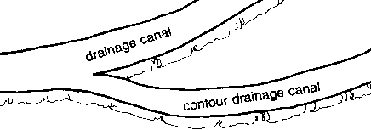
Contour drainage canal

Soil block
4. Contour bund is the firm mound of soil formed during the
construction of the canals. During rain, water and the soil carried by it are
initially collected at the depression at the. base of the mound and the strip.
The excess water and the soil canted by it collect at the canal before the mound
or bund, in case canal is below the bund or by the canal in case the bund is
below the canal.

Before and after
5. Check Dams Moving water dislodges soil particles and carry
these particles away, thus causing erosion. A check dam slows down water flow
and allows heavier soil particles to settle down.

Check dams
· In a drainage system, drive
stakes into the ground, perpendicular to the water flow.
Gliricildia makes an
ideal "live" peg if it is available. The cuttings will grow and form a permanent
living barrier. Arrow root and vetiver grass planted across the canal will serve
as good check dam.
· Weave split bamboo strips
between the pegs but not very closely. The aim is not to stop the water but to
slow down its flow. Periodically clean the area above the dam.
· Begin constructing dams from
the top portion of the drainage canal or gully. The steeper the slope, the
closer together the dam should be.
6. Soil traps. The purpose of this structure is to catch soil
carried by water in a drainage system and to slow water flow. It is placed about
1/2 m above a check dam.

Soil trap
· In a drainage system (drainage
diversion canal, contour-drainage canal or gully), dig a pit at least 0.8 m.
deep × 1.00 m long and 0.5 m wide.
· Clean the pit periodically and
spread the soil on the
farm.
8. Bench Terraces
The process of levelling the land for agricultural or other
purposes is called bench terracing. It is generally done where there is deep
heavy clay soil rather than in very sandy soil. The most direct method is called
the cut and fill procedure and requires several steps These are:

Area
1. Using an A-frame, mark at least two contour lines on a
hillside. The vertical distance should not be more than 1.5 meters. Generally,
the vertical distance will be about 1.0 meter. The distance along the slope will
vary. The more gentle the slope. the further apart the contour lines.
Find the midline
2. Find the midline between the two contour lines.
3. Using draft animals or hand tools such as shovels, begin
removing the soil from the upper half of the strip, i.e., midline to upper
contour line (the cut) and place it on the lower half (the fill).
4. Continue the process until the area above the midline and the
soil piled below the midline are levelled.
5. The front of the level area called the riser should be
constructed so it slants back toward the hillside. The angle of the riser should
be between 15° and 45° depending upon the type of soil and the riser
height. The angling of the riser will give it more stability. Further riser
stabilization is done by planting the riser with grasses.
6. A small canal is excavated at the base of the terrace. This
canal is used to carry off excess rain water during heavy rains and saves the
terrace below from being washed away. Care must be taken to integrate the
drainage of the bench terrace into the overall drainage system of the farm
7. Slope the new front area of the terrace slightly upwards. At
the front of the terrace and on the top of the riser, construct a small mound or
lip. This will prevent water from washing over the front and eroding the riser

Cross section showing riser lip
CONSIDERATIONS:
1. Bench terracing is the most labor intensive and the most
expensive of the land-levelling processes and often requires draft animal power.
2. A scraper/scoop can be used to help in moving soil. The
scraper consists of blade made of a solid plank of wood or metal with a handle
attached and a strong rope (4 m. length) attached to the top of the blade (base
of the handle). The scraper is operated by two men. One places the blade into
cultivated soil. The other, guided by the man with the handle, pulls the scraper
towards the fill area. If draft animals are available, the area can be plowed
first to facilitate soil movement. The blade can be attached to and pulled by
draft animals.

Two-man scraper
3. Frequently, top soil from the proposed terracing areas is
removed and stock piled on the side. The base of the bench terrace is
constructed using subsoil from the cut area and then the top soil is placed back
on the surface. The process is time consuming but ensures good will remains on
the surface.
4. Several different materials may be used to stabilize the
riser. These include Bermuda grass Cynodon sp.,Napier grass Pennisetum
purpureum, "Hetero", Desmodium heterophyla.
5. In some areas of the country, legume hedgerows are placed at
the top of the riser and constantly pruned to generate green manure or animal
feeds. vetiYer grass may also be planted on the lip.

Legume hedgerow on terraces
6. Rockwalls are frequently used to create a more permanent
riser. (See Terraced Land Agncultural Technology, page 81.)
7. To protect the above newly terraced area, a drainage canal
can be constructed across the top of the farm and excess water from land above
the farm can be diverted around the farm. Care must be taken to stabilize the
canal and the gully into which the water flows. This is especially true on steep
slopes.
8. Care should be taken that a finished riser height is not too
tall. When one terrace is linked to the one below it, the riser height is the
same as the vertical distance between contours. Riser heights of over one meter
are difficult to climb. For example, if the vertical distance between contour
lines is 20 meters, the riser height of one terrace is 10 meter.
This is fine until another bench terrace is built above or
below. If the new riser also has a 2.0 m vertical height between contours, the
common riser between the two benches will be 2.0 m. A farmer would need a ladder
to climb over the riser. It would ' he more unstable because of its height.

A riser is too high
9. The bench terrace requires maintenance. The canal at the back
should be constantly cleaned, the riser checked and its cover maintained, If
hedgerows are present, they should be regularly pruned.
10. Comparison of bench terracing with other soil conservation
structures:
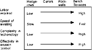
Figure
11. Rockwalls are sometimes used to stabilize the riser and the
terrace used for both wet land and dry land crops. (See Terraced Agricultural
Land Technology)
TERRACED AGRICULTURAL LAND TECHNOLOGY (TALT)
This farm technology was observed in Patlabawon. Patnongon,
Antique, and dates back to the early 1900s. In some parts of Cebu, this practice
has likewise been observed. A more extensive proof of this technology is the
irrigated rice paddies of the Cordillera, particularly the Banaue rice terraces.
Materials include stones or rocks, A-frame, carabao or cow,
plow, flat bar, pick mattock, hoe, spade or shovel, wooden plank.
Procedure:
1. Locate a site with good soil and where stones/boulders are
abundant

Plow line on hillside at soil height

2. Establish the contour using an
A-frame

3. Collect stones/rocks and prepare
them below the identified contour line
4. Plow and dig the identified contour deep enough to accomodate
the initial foundation of big stones. Set the initial stones on angle towards
the slope.
5. Pile rocks stones gradually in a manner that they fit and
lock each other. Fill in the gaps with smaller stones and clayey soil to
minimize leakage. The heavier end of the rock or boulder must be piled facing
the hill for greater stability. The base of the rockwall must be always wider
than the top. The inclination of the rockwall should be between 5-10 degrees
from the vertical axis.
6. Plow to loosen the upper portion of the slope and move the
soil using a harrow mounted with a wooden plank towards the rockwalls if soils
are deep.
7. After attaining the desired level of the soil, construct a
dike on the soil surface adjacent to the top of the rockwall. This will create a
holding area for water.
8. Terrace building starts from the bottom and proceeds uphill.
In severely eroded areas like Cebu, the farmers start building from the upper
slope.
9. Prepare the field for planting of rice during rainy months
and corn/tobacco/vegetables during summer.
10. Plant forest and fruit trees on the upper portion of the
hill and some leguminous species around the terraced area to minimize soil
erosion and enhance water accumulation.
CONSIDERATIONS:
1. The distance between contour lines depends on the
farm plan and the farm situation.
2. The height of the rockwalls depend on the availability of
stones/rocks in the area, farm situation and farm plan.
3. This labor intensive technology is best done through alayon
or dagyaw (bayanihan) or mutual labor sharing (man and animal).
4. To break big stones, heat and pour tap water over the rock
before breaking with pick mattock.
ESTIMATED COST OF CONSTRUCTION OF TERRACED RICE PADDY
1. Construction of Rock walls (Gathering and Piling
of Rocks) Rockwall Dimension:
1.0 meter base
1.0 meter high
0.5
meter top
Rate: 2 linear meters per person day
2. Diversion of Soil a. Average of 2 cubic meters per person day
b. Average of 8 cubic per person/animal day at P15 00/cubic meter
3. Leveling the Rice Paddy 112 Hectare per person/animal day
4. Construction of Paddy Dikes (Dimension 30 × 60 cu
m)
Average of 9 linear meters per person
day